Share our site:

SHARE
166
Atlas of the Mediterranean. ROUX. Carte de la mer Mediterranée en douze feuilles.
1764
EUR 4.000,00
Base d'asta
EUR 6.000,00 / 7.000,00
Stima
Descrizione
Atlas of the Mediterranean. ROUX. Carte de la mer Mediterranée en douze feuilles.
1764
1764
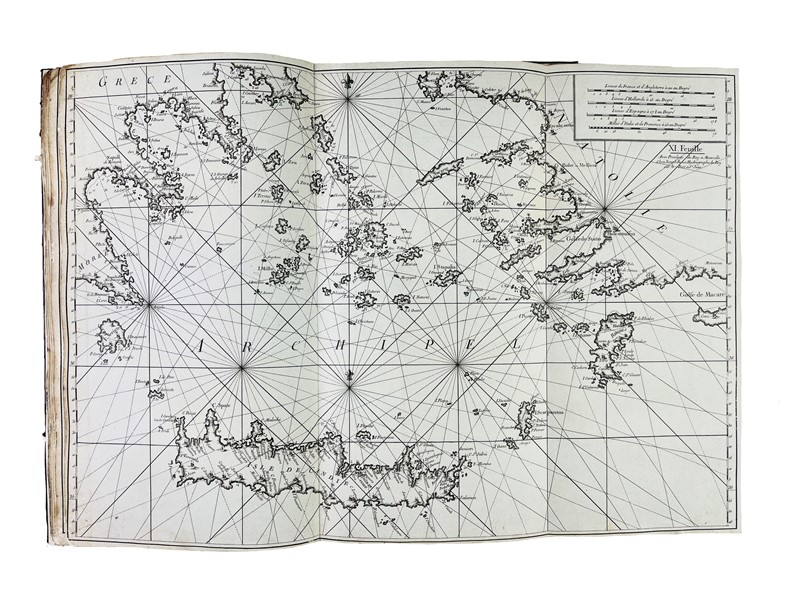
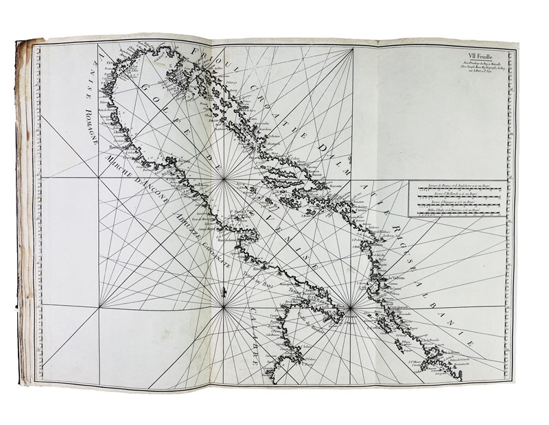
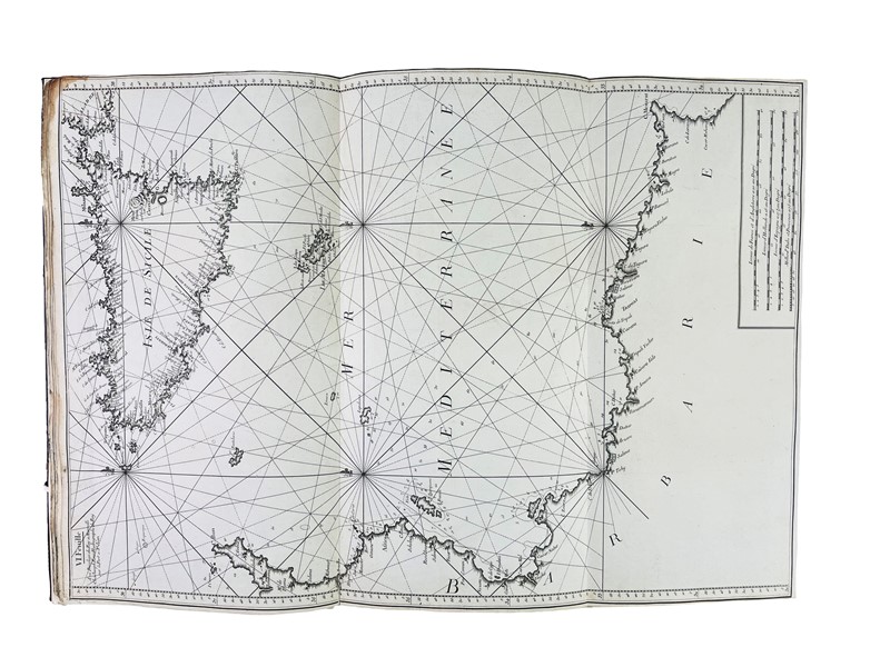
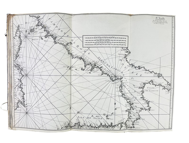
ROUX, Joseph. Carte de la mer Mediterranée en douze feuilles, dédiée à M.gr le Duc de Choiseul Colonel General des Suisses et Grisons. Ministre de la Guerre et de la Marine.
Marsiglia, 1764
In Folio, 567x310 mm. Legatura in tutta pelle coeva di recupero con restauro conservativo al piatto inferiore con lacci in pelle bianca. Sguardie nuove. 12 carte nautiche incise in rame, su carta forte azzurrata e bianca, che misurano circa 550x800 mm. La legatura proviene da un esemplare del medesimo atlante delledizione pubblicata da Gravier e a Genova, come testimonia lelenco delle tavole applicato allinterno del piatto. Alcuni aloni e macchie al verso della prima e dellultima carta.
Atlante del Mediterraneo che in 12 carte raffigura tutte le coste, i porti e gli ancoraggi. Fu molto stimato ed ebbe notevole successo tanto che è noto che pure lammiraglio Nelson ne avesse un esemplare a bordo della Victory. Venne poi stampato per circa 40 anni. La prima carta raffigura lo stretto di Gibilterra, lultima i Dardanelli. Le carte costiere, tipiche dei cartografi del XVIII secolo e con un aspetto simile alle carte inglesi di Grenville Collins e Mount & Page, mostrano fondali, porti, fortificazioni e città dell'intera costa mediterranea: da Cadice e lo Stretto di Gibilterra alla costa levantina con tutte le isole e le coste intermedie, tra cui Sicilia, Corsica e Sardegna, Malta, l'Adriatico, Cipro, Grecia, Algeria, Egitto e la costa africana. Le carte di Roux furono le migliori dell'epoca per quest'area.
Blackmer 1455; NMM 3: 267; Phillips 195; Shirley, BL, M. Roux 2-a; Tooley 550.
Condition Report
ROUX, Joseph. Carte de la mer Mediterranée en douze feuilles, dédiée à M.gr le Duc de Choiseul Colonel General des Suisses et Grisons. Ministre de la Guerre et de la Marine.
Marsiglia, 1764
In Folio, 567x310 mm. Contemporary full-leather binding, salvaged with conservative restoration on the lower cover with white leather laces. Renewed endpapers. 12 copper-engraved nautical charts on thick blue and white paper, measuring approximately 550 x 800 mm. The binding is from a copy of the same atlas as the edition published by Gravier and in Genoa, as evidenced by the list of plates applied inside the cover. Some stains on the verso of the first and last pages.
Atlas of the Mediterranean, featuring 12 maps of all coasts, ports and anchorages. It was highly regarded and so successful that Admiral Nelson is known to have had one aboard the Victory. It was subsequently printed for approximately 40 years. The first map depicts the Strait of Gibraltar, the last the Dardanelles.
The coastal charts, typical of 18th century cartographer with a somewhat similar appearance to the English charts of Grenville Collins and Mount & Page, show depths, ports, fortifications and towns of the entire Mediterranean coast: from Cadiz and the Strait of Gibraltar to the Levantine coast with all islands and coastlines in between, including Sicily, Corsica and Sardinia, Malta, the Adriatic, Cyprus, Greece, Algeria, Egypt and the African coast. Roux's charts were the best of the age of this area.
Blackmer 1455; NMM 3: 267; Phillips 195; Shirley, BL, M.Roux 2-a; Tooley 550.
Bibliografia
Blackmer 1455; NMM 3: 267; Phillips 195; Shirley, BL, M. Roux 2-a; Tooley 550.
mer 18 Febbraio 2026
Orari Asta
Via dei Soncin, 28 35122 Padova
ESIBIZIONE: 13-16 Febbraio 2026 solo su appuntamento.
Per prenotare il vostro appuntamento chiamare il numero 049 8755317 o mandare una email a info@badoemart.it
Ricordiamo che il nostro staff rimane a vostra disposizione per eseguire condition report dettagliati con foto aggiuntive a quelle già presenti in catalogo.
Bado e Mart
https://www.badoemart.it/img-footer/logo.png
Bado e Mart Srl
Via Dei Soncin, 28
35122 Padova Veneto Italy
Tel. +39 049 8755317
Fax +39 049 8755317
E-mail: info@badoemart.it
Partita IVA IT00773300280
35122 Padova Veneto Italy
Tel. +39 049 8755317
Fax +39 049 8755317
E-mail: info@badoemart.it
Partita IVA IT00773300280
Follow us on
Copyright Bado e Mart 2018. All rights reserved.
Realized by Thetis Srl
Realized by Thetis Srl