Share our site:

SHARE
185
Pocket Atlas. LOTTER. Atlas Geographicus Portabilis XXXIX Mappis Orbis Habitabilis Regna.
EUR 1.000,00
Base d'asta
EUR 1.500,00 / 2.000,00
Stima
Descrizione
Pocket Atlas. LOTTER. Atlas Geographicus Portabilis XXXIX Mappis Orbis Habitabilis Regna.
LOTTER, Tobias Conrad - LOBECK, Tobias. Atlas geographicus portatilis, XXIX. mappis orbis habitabilis regna exhibens - Kurzgefasste Geographie, in sich haltend einen aneinander hangenden Entwurf aller Theile des bevvohnten Erdbodens
Augspurg [sic, i.e. Augsburg], Allda gedruckt bey Johann Michael Spaeth, [1662 ca]
2 parti in un volume in 8vo oblungo, 110x137 mm. Legatura in pelle coeva con impressioni a secco. Così composto: Antiporta incisa, Frontespizio inciso, 43 mappe incise in rame con coloritura coeva, Indice delle 29 Mappe dellAtlas inciso, al verso lista manoscritta delle 14 Mappe aggiunte, Pagine 72, compreso il Frontespizio a stampa Kurzgefasste Geographie. Mappe con numerazione manoscritta I-XXI, 1-14, XXII-XXIX. Scritte delle mappe per lo più in latino, altrimenti in tedesco e francese. Sul verso dellAntiporta e sul Frontespizio inciso, timbro di dismissione di antica biblioteca monastica. In totale 45 tavole incise su doppia pagina. Leggermente ingiallito e con lievi fioriture in alcuni punti.
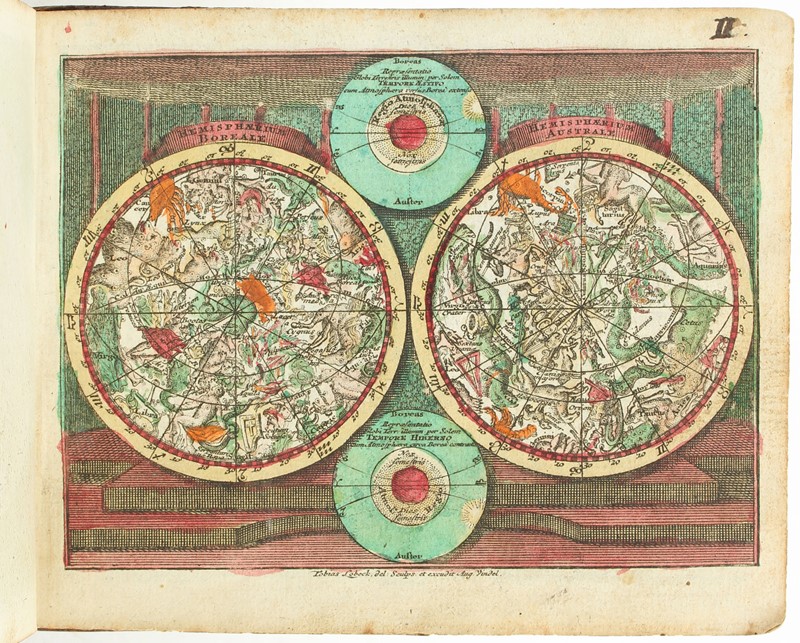
Raro atlante portatile, con coloritura contemporanea. Edizione ampliata rispetto allindice, integrato da 14 carte geografiche. Di notevole gusto ed eleganza, lantiporta e il frontespizio sono incisi da Tobias Lobeck su disegno di Gottfried Eichler. Le mappe sono incise da Tobias Lotter dai disegni di Tobias Lobeck. L'Atlante include: una mappa del mondo a doppio emisfero, un planisfero celeste, mappe di Europa, Asia, Africa e Americhe, e di vari paesi e regioni d'Europa, molte delle quali ornate da un cartiglio. La mappa intitolata "America" mostra sia il Nord che il Sud America, con la parte settentrionale in una fase alquanto incompleta, poiché quest'area era ancora in gran parte inesplorata. Nella mappa dell'Asia, la costa settentrionale dell'Australia. In questo esemplare sono aggiunte 14 mappe della Germania, inserite dopo la Mappa XXI. La mappa intitolata "America" mostra sia il Nord che il Sud America con la parte settentrionale in una fase alquanto incompiuta, poiché quest'area era ancora in gran parte inesplorata. Nella mappa dell'Asia compare la costa settentrionale dell'Australia.
La distruzione di Lima del 1746 è menzionata nel testo, a pagina 71, come avvenuta lanno prima: questa edizione, tuttavia, fu pubblicata successivamente poiché lo stampatore Spaeth subentrò al precedente editore J.M. Wagner, il quale acquistò le stampe nel 1754 e morì nel 1758.
King: The atlas was sold both with and without Lobecks undated pocket geography ... which was printed first by A. Brinhauser, then Johann Michael Wagner and lastly by Johann Michael Spaeth
Shirley T.LOT-1a (29 Karten), Pagliani, Atlas minor 43; Phillips 630. Cfr. King, Miniature Maps 1744 (online).
Condition Report
LOTTER, Tobias Conrad - LOBECK, Tobias. Atlas geographicus portatilis, XXIX. mappis orbis habitabilis regna exhibens - Kurzgefasste Geographie, in sich haltend einen aneinander hangenden Entwurf aller Theile des bevvohnten Erdbodens. Augsburg [sic, i.e. Augsburg], Allda gedruckt bey Johann Michael Spaeth, [1662 ca]
Two parts in one oblong 8vo volume, 110 x 137 mm. Contemporary leather binding with blind tooling
Consists of: Engraved frontispiece, engraved title page, 43 copper-engraved maps with contemporary coloring, Index of the 29 Maps of the engraved Atlas, on the verso a handwritten list of the 14 additional maps, 72 pages, including the printed title page 'Kurzgefasste Geographie'. Maps with handwritten numbering I-XXI, 1-14, XXII-XXIX. Map inscriptions mostly in Latin, otherwise in German and French. On the verso of the frontispiece and on the engraved title page, a stamp of dismissal of an ancient monastic library. A total of 45 engraved plates on a double page. Slightly yellowed and with some light foxing in some areas.
Rare portable atlas, with contemporary coloring. This expanded edition, supplemented by 14 maps, includes a table of contents. The frontispiece and title page are engraved by Tobias Lobeck from drawings by Gottfried Eichler, and are of remarkable taste and elegance. The maps are engraved by Tobias Lotter from drawings by Tobias Lobeck. The atlas includes a double-hemispheric world map, a celestial planisphere, maps of Europe, Asia, Africa, and the Americas, and various European countries and regions, many of which are adorned with cartouches. The map entitled "America" shows both North and South America, with the northern portion still incomplete, as this area was still largely unexplored. The map of Asia includes the northern coast of Australia. This example includes 14 maps of Germany, inserted after Map XXI. The map titled "America" shows both North and South America, with the northern portion somewhat unfinished, as this area was still largely unexplored. In the map of Asia, he compares the northern coast of Australia.
The destruction of Lima in 1746 is mentioned in the text, on page 71, as having occurred the previous year; this edition, however, was published later, as the printer Spaeth took over from the previous publisher J.M. Wagner, who purchased the prints in 1754 and died in 1758.
King: Latlante è stato venduto sia con che senza la geografia tascabile senza data di Lobeck che è stata stampata prima da A. Brinhauser, poi da Johann Michael Wagner e infine da Johann Michael Spaeth
Shirley T.LOT-1a (29 Karten), Pagliani, Atlante minore 43; Phillips 630. Cfr. Re, mappe in miniatura 1744 (in linea).
Bibliografia
King, Miniature Maps 1744 (online); Shirley T. LOTT-1a; Pagliani, Atlas Minor 43 e Phillips 631f.
mer 18 Febbraio 2026
Orari Asta
Via dei Soncin, 28 35122 Padova
ESIBIZIONE: 13-16 Febbraio 2026 solo su appuntamento.
Per prenotare il vostro appuntamento chiamare il numero 049 8755317 o mandare una email a info@badoemart.it
Ricordiamo che il nostro staff rimane a vostra disposizione per eseguire condition report dettagliati con foto aggiuntive a quelle già presenti in catalogo.
Bado e Mart
https://www.badoemart.it/img-footer/logo.png
Bado e Mart Srl
Via Dei Soncin, 28
35122 Padova Veneto Italy
Tel. +39 049 8755317
Fax +39 049 8755317
E-mail: info@badoemart.it
Partita IVA IT00773300280
35122 Padova Veneto Italy
Tel. +39 049 8755317
Fax +39 049 8755317
E-mail: info@badoemart.it
Partita IVA IT00773300280
Follow us on
Copyright Bado e Mart 2018. All rights reserved.
Realized by Thetis Srl
Realized by Thetis Srl